|
|
USGS 3DEP (3D Elevation Program)
The 3D Elevation Program is managed by the U.S. Geological Survey (USGS) National Geospatial Program to respond to growing needs for high-quality topographic data and for a wide range of other three-dimensional (3D) representations of the Nation's natural and constructed features. 3DEP informs critical decisions that are made across our Nation every day that depend on elevation data, ranging from immediate safety of life, property, and environment to long term planning for infrastructure projects.
3DEP is based on the results of the National Enhanced Elevation Assessment (NEEA) that was funded by National Digital Elevation Program (NDEP) agencies and completed in 2012. The study, led by the USGS, identified more than 600 requirements for enhanced (3D) elevation data to address mission-critical information requirements of 34 Federal agencies, all 50 States, and a sample of private sector companies and Tribal and local governments.
The first full year of 3DEP production began in 2016 and at the end of fiscal year 2023, 94.7% of the Nation has available or in progress elevation data that meet 3DEP specifications for high accuracy and resolution.
The USGS 3D Elevation Program (3DEP) is collecting high-quality lidar and IfSAR (for Alaska) coverage for all of the United States and its territories.
|
ChartTiff 3D Elevation Program
-
Complete Coverage of the Continental US, AK, HI and PR/VI
-
Horizontal Resolutions Available
-
10 Meter
(1/3 Arc Second)
resolution for Continental US, AK, HI and PR/VI
-
30 Meter
(1 Arc Second)
resolution for Continental US, AK, HI and PR/VI
Generated from the 10-Meter 3DEPs
-
3DEP Quads are made rectangular data sets to be compatible with ChartTiff Topographic Maps
-
File names compatible with USGS DRG Quad naming standard
-
Vertical Resolution: 1 DeciMeter or 10 CM or approximately 4 Inches.
-
Vertical Datum: NAVD88
-
Creation Date from Metadata file included in ChartTiff's Order.txt file.
Complete Metadata.xml file available while viewing Thumbnails.
-
Order by:
-
Formmats Available:
-
USGS Standard DEM file format
-
GeoTIFF Format, includes ".tfw" world file
-
ESRI Grid Float Format
-
PLS-CADD ASCII Text, X,Y,Z format
XYZ text file format specifically for PLS CADD Software
-
ASCII Text, X,Y,Z format
XYZ text file format is a simple text format
where each elevation point is described by x, y, and z coordinates.
The x value defines the east/west coordinate,
y defines the north/south coordinate, and
z defines the elevation.
User can select Tab, Comma or Space delimited file.
The XYZ text format does not contain any header information:
x1,y1,z1
x2,y2,z2
x3,y3,z3
.....
xn,yn,zn
-
C Tech File Format
GMF and EFF files, directly read by C Tech Software
-
Available Projections
-
UTM - User Selectable Zones - NAD27 / NAD83 / WGS72 / WGS84
-
State Plane - User Selectable Zones - NAD27 / NAD83
-
Latitude / Longitude - NAD27 / NAD83 / WGS72 / WGS84
-
Web Mercator
- WGS84
-
Optional Shaded Elevation Models can be added as an additional file.
Click Here for Additional Information.
-
A 3DEP Quad is available as
1 Free Download
|
|
|
|
USGS NED (National Elevation Dataset)
The National Elevation Dataset (NED) was the primary elevation data product that was produced and distributed by the U.S. Geological Survey (USGS). Since its inception, the USGS compiled and published topographic information in many forms, and the NED was a significant development in this long line of products that describe the land surface. The NED provided seamless raster elevation data of the conterminous United States (CONUS), Alaska, Hawaii, U.S. island territories, Mexico, and Canada. The NED was derived from diverse source datasets that are processed to a specification with consistent resolutions, coordinate system, elevation units, and horizontal and vertical datums. The NED was developed as the logical result of the maturation of the long-standing USGS elevation program, which for many years concentrated on production of quadrangle-based digital elevation models (DEM).
For over 15 years (1999–2014), the NED served as the flagship elevation product of the USGS. In 2015, the 3D Elevation Program (3DEP) was initiated. When the 3DEP initiative became operational, the name “National Elevation Dataset” (and the abbreviation “NED”) were retired as the USGS elevation activities and data were rebranded under the 3DEP banner. However, elevation data produced and distributed as part of the NED are still widely used.
Data corrections were made in the NED assembly process to minimize artifacts, perform edge matching, and fill sliver areas of missing data. NED data sources had a variety of acquisition techniques, elevation units, horizontal datums, and map projections. In the NED assembly process the elevation values were converted to deci-meters as a consistent unit of measure, NAD83 is consistently used as horizontal datum, and all the data are recast in a geographic projection. Older DEM's produced by methods that are now obsolete have been filtered during the NED assembly process to minimize artifacts that are commonly found in data produced by these methods. Artifact removal greatly improved the quality of the slope, shaded-relief, and synthetic drainage information that can be derived from the elevation data. The figure below illustrates the results of this artifact removal filtering. NED processing also included steps to adjust values where adjacent DEM's do not match well, and to fill sliver areas of missing data between DEM's. These processing steps ensured that NED has no void areas and artificial discontinuities were minimized.
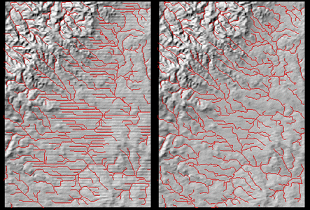
Figure. A shaded-relief representation of the Rockypoint, Wyoming 7.5-minute DEM is shown above on the left.
The same area is shown on the right after NED artifact filtering has been performed.
The super-imposed red lines are synthetic drainage networks derived from each elevation dataset.
|
ChartTiff National Elevation Data
-
Horizontal Resolutions Available
-
3 Meter (1/9 Arc Second) resolution
-
Approximately 31% of the Continental United States in 3 Meter (1/9 Arc-Second) Resolution
-
Note:
Due to the acquisition region specified during the acquiring of the 3 Meter (1/9 Arc-Second) data used by the USGS, ChartTiff quads or custom areas may not be complete.
Users are notified when a 3 meter ChartTiff quad is not complete.
-
10 Meter
(1/3 Arc Second)
resolution for Continental US
-
30 Meter
(1 Arc Second)
resolution for Continental US, HI, PR and VI
-
60 Meter
(2 Arc Second)
resolution for Alaska
-
NED Quads are made rectangular data sets to be compatible with
ChartTiff Topographic Maps
-
File names compatible with USGS DRG Quad naming standard
-
Vertical Resolution: 1 DeciMeter or 10 CM or approximately 4 Inches.
-
Vertical Datum: NAVD88
-
Vertical Accuracy, See:
USGS NED Accuracy Paper
-
Creation Date from Metadata file included in ChartTiff's Order.txt file.
-
Order by:
-
Formmats Available:
-
USGS Standard DEM file format
-
GeoTIFF Format, includes ".tfw" world file
-
ESRI Grid Float Format
-
PLS-CADD ASCII Text, X,Y,Z format
XYZ text file format specifically for PLS CADD Software
-
ASCII Text, X,Y,Z format
XYZ text file format is a simple text format
where each elevation point is described by x, y, and z coordinates.
The x value defines the east/west coordinate,
y defines the north/south coordinate, and
z defines the elevation.
User can select Tab, Comma or Space delimited file.
The XYZ text format does not contain any header information:
x1,y1,z1
x2,y2,z2
x3,y3,z3
.....
xn,yn,zn
-
C Tech File Format
GMF and EFF files, directly read by C Tech Software
-
Available Projections
-
UTM - User Selectable Zones - NAD27 / NAD83 / WGS72 / WGS84
-
State Plane - User Selectable Zones - NAD27 / NAD83
-
Latitude / Longitude - NAD27 / NAD83 / WGS72 / WGS84
-
Web Mercator
- WGS84
-
Optional Shaded Elevation Models can be added as an additional file.
Click Here for Additional Information.
-
A NED Quad is available as
1 Free Download
|
|
|
|
USGS DEM (Digital Elevation Model)
A Digital Elevation Model (DEM) is a representation of the bare ground (bare earth) topographic surface of the Earth excluding trees, buildings, and any other surface objects.
Legacy DEMs were produced from cartographic contours derived from hand-drawn topographic maps.
USGS DEMs were replaced by NEDs (National Elevation Dataset) in 1999.
|
ChartTiff Digital Elevation Model
-
Complete Coverage of the Continental US in 30 or 60 Meter resolutions
Models contain ODB level 1 / 2 data.
-
Models all voided and slivered areas filled
-
Quads are made rectangular data sets to be compatible with
ChartTiff Topographic Maps
-
File names compatible with USGS DRG Quad naming standard
-
Horizontal Resolutions Available
-
30 Meter
(1 Arc Second)
resolution for Continental US
-
60 Meter
(2 Arc Second)
resolution for Continental US
Generated from the 30-Meter DEMs
-
Vertical Datum: 1929 (NGVD 29)
-
USGS DEM (Digital Elevation Model) format documentation:
-
Creation Date from Metadata file included in ChartTiff's Order.txt file.
-
Order by:
-
Formmats Available:
-
USGS Standard DEM file format
-
GeoTIFF Format, includes ".tfw" world file
-
ESRI Grid Float Format
-
PLS-CADD ASCII Text, X,Y,Z format
XYZ text file format specifically for PLS CADD Software
-
ASCII Text, X,Y,Z format
XYZ text file format is a simple text format
where each elevation point is described by x, y, and z coordinates.
The x value defines the east/west coordinate,
y defines the north/south coordinate, and
z defines the elevation.
User can select Tab, Comma or Space delimited file.
The XYZ text format does not contain any header information:
x1,y1,z1
x2,y2,z2
x3,y3,z3
.....
xn,yn,zn
-
C Tech File Format
GMF and EFF files, directly read by C Tech Software
-
Available Projections
-
UTM - User Selectable Zones - NAD27 / NAD83 / WGS72 / WGS84
-
State Plane - User Selectable Zones - NAD27 / NAD83
-
Latitude / Longitude - NAD27 / NAD83 / WGS72 / WGS84
-
Web Mercator
- WGS84
-
Optional Shaded Elevation Models can be added as an additional file.
Click Here for Additional Information.
-
A DEM Quad is available as
1 Free Download
|
|
|
|